Wolfram Archive
Wolfram Programming Lab is a legacy product.
All the same functionality and features, including access to Programming Lab Explorations, are available with Wolfram|One.
Start programming now. »

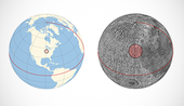
Sister Spot on the Moon

Find where your location on the Earth corresponds to the Moon.

Run the code to mark your location on a map of the world:

SHOW/HIDE DETAILS

Mark your position on a map:

GeoGraphics[GeoMarker[Here]]

Expand the view to the whole world:

GeoGraphics[GeoMarker[Here], GeoRange -> All]

HIDE DETAILS
GeoGraphics[GeoMarker[Here], GeoRange -> All]

Draw a red disk around your position. Try other radius values:

SHOW/HIDE DETAILS

Draw a disk with a 200-mile radius centered at your location. To specify the 200-mile radius, type += to get a natural language input box and type 200 miles:

GeoGraphics[GeoDisk[Here, \!\(\* NamespaceBox["LinguisticAssistant", DynamicModuleBox[{Typeset`query$$ = "200 miles", Typeset`boxes$$ = TemplateBox[{"200", "\"mi\"", "miles", "\"Miles\""}, "Quantity", SyntaxForm -> Mod], Typeset`allassumptions$$ = {}, Typeset`assumptions$$ = {}, Typeset`open$$ = {1}, Typeset`querystate$$ = { "Online" -> True, "Allowed" -> True, "mparse.jsp" -> 1.618263`6.6605940980199225, "Messages" -> {}}}, DynamicBox[ToBoxes[ AlphaIntegration`LinguisticAssistantBoxes["", 4, Automatic, Dynamic[Typeset`query$$], Dynamic[Typeset`boxes$$], Dynamic[Typeset`allassumptions$$], Dynamic[Typeset`assumptions$$], Dynamic[Typeset`open$$], Dynamic[Typeset`querystate$$]], StandardForm], ImageSizeCache->{72., {7., 16.}}, TrackedSymbols:>{ Typeset`query$$, Typeset`boxes$$, Typeset`allassumptions$$, Typeset`assumptions$$, Typeset`open$$, Typeset`querystate$$}], DynamicModuleValues:>{}, UndoTrackedVariables:>{Typeset`open$$}], BaseStyle->{"Deploy"}, DeleteWithContents->True, Editable->False, SelectWithContents->True]\)], GeoRange -> All]

Make the disk easier to see by coloring it red and giving it a black edge:

GeoGraphics[{Red, EdgeForm[Black], GeoDisk[Here, \!\(\* NamespaceBox["LinguisticAssistant", DynamicModuleBox[{Typeset`query$$ = "200 miles", Typeset`boxes$$ = TemplateBox[{"200", "\"mi\"", "miles", "\"Miles\""}, "Quantity", SyntaxForm -> Mod], Typeset`allassumptions$$ = {}, Typeset`assumptions$$ = {}, Typeset`open$$ = {1}, Typeset`querystate$$ = { "Online" -> True, "Allowed" -> True, "mparse.jsp" -> 1.618263`6.6605940980199225, "Messages" -> {}}}, DynamicBox[ToBoxes[ AlphaIntegration`LinguisticAssistantBoxes["", 4, Automatic, Dynamic[Typeset`query$$], Dynamic[Typeset`boxes$$], Dynamic[Typeset`allassumptions$$], Dynamic[Typeset`assumptions$$], Dynamic[Typeset`open$$], Dynamic[Typeset`querystate$$]], StandardForm], ImageSizeCache->{72., {7., 16.}}, TrackedSymbols:>{ Typeset`query$$, Typeset`boxes$$, Typeset`allassumptions$$, Typeset`assumptions$$, Typeset`open$$, Typeset`querystate$$}], DynamicModuleValues:>{}, UndoTrackedVariables:>{Typeset`open$$}], BaseStyle->{"Deploy"}, DeleteWithContents->True, Editable->False, SelectWithContents->True]\)]}, GeoRange -> All]

HIDE DETAILS
GeoGraphics[{Red, EdgeForm[Black], GeoDisk[Here, \!\(\* NamespaceBox["LinguisticAssistant", DynamicModuleBox[{Typeset`query$$ = "200 miles", Typeset`boxes$$ = TemplateBox[{"200", "\"mi\"", "miles", "\"Miles\""}, "Quantity", SyntaxForm -> Mod], Typeset`allassumptions$$ = {}, Typeset`assumptions$$ = {}, Typeset`open$$ = {1}, Typeset`querystate$$ = { "Online" -> True, "Allowed" -> True, "mparse.jsp" -> 1.618263`6.6605940980199225, "Messages" -> {}}}, DynamicBox[ToBoxes[ AlphaIntegration`LinguisticAssistantBoxes["", 4, Automatic, Dynamic[Typeset`query$$], Dynamic[Typeset`boxes$$], Dynamic[Typeset`allassumptions$$], Dynamic[Typeset`assumptions$$], Dynamic[Typeset`open$$], Dynamic[Typeset`querystate$$]], StandardForm], ImageSizeCache->{77., {7., 16.}}, TrackedSymbols:>{ Typeset`query$$, Typeset`boxes$$, Typeset`allassumptions$$, Typeset`assumptions$$, Typeset`open$$, Typeset`querystate$$}], DynamicModuleValues:>{}, UndoTrackedVariables:>{Typeset`open$$}], BaseStyle->{"Deploy"}, DeleteWithContents->True, Editable->False, SelectWithContents->True]\)]}, GeoRange -> All]

Mark the corresponding position on the Moon:

SHOW/HIDE DETAILS

The Moon has a {latitude,longitude} coordinate system just like Earths.

Mark your Earth {latitude,longitude} on the Moons coordinate system:

GeoGraphics[{Red, EdgeForm[Black], GeoDisk[Here, \!\(\* NamespaceBox["LinguisticAssistant", DynamicModuleBox[{Typeset`query$$ = "200 miles", Typeset`boxes$$ = TemplateBox[{"200", "\"mi\"", "miles", "\"Miles\""}, "Quantity", SyntaxForm -> Mod], Typeset`allassumptions$$ = {}, Typeset`assumptions$$ = {}, Typeset`open$$ = {1}, Typeset`querystate$$ = { "Online" -> True, "Allowed" -> True, "mparse.jsp" -> 1.618263`6.6605940980199225, "Messages" -> {}}}, DynamicBox[ToBoxes[ AlphaIntegration`LinguisticAssistantBoxes["", 4, Automatic, Dynamic[Typeset`query$$], Dynamic[Typeset`boxes$$], Dynamic[Typeset`allassumptions$$], Dynamic[Typeset`assumptions$$], Dynamic[Typeset`open$$], Dynamic[Typeset`querystate$$]], StandardForm], ImageSizeCache->{72., {7., 16.}}, TrackedSymbols:>{ Typeset`query$$, Typeset`boxes$$, Typeset`allassumptions$$, Typeset`assumptions$$, Typeset`open$$, Typeset`querystate$$}], DynamicModuleValues:>{}, UndoTrackedVariables:>{Typeset`open$$}], BaseStyle->{"Deploy"}, DeleteWithContents->True, Editable->False, SelectWithContents->True]\)]}, GeoRange -> All, GeoModel -> Entity["PlanetaryMoon", "Moon"]]

HIDE DETAILS
GeoGraphics[{Red, EdgeForm[Black], GeoDisk[Here, \!\(\* NamespaceBox["LinguisticAssistant", DynamicModuleBox[{Typeset`query$$ = "200 miles", Typeset`boxes$$ = TemplateBox[{"200", "\"mi\"", "miles", "\"Miles\""}, "Quantity", SyntaxForm -> Mod], Typeset`allassumptions$$ = {}, Typeset`assumptions$$ = {}, Typeset`open$$ = {1}, Typeset`querystate$$ = { "Online" -> True, "Allowed" -> True, "mparse.jsp" -> 1.618263`6.6605940980199225, "Messages" -> {}}}, DynamicBox[ToBoxes[ AlphaIntegration`LinguisticAssistantBoxes["", 4, Automatic, Dynamic[Typeset`query$$], Dynamic[Typeset`boxes$$], Dynamic[Typeset`allassumptions$$], Dynamic[Typeset`assumptions$$], Dynamic[Typeset`open$$], Dynamic[Typeset`querystate$$]], StandardForm], ImageSizeCache->{77., {7., 16.}}, TrackedSymbols:>{ Typeset`query$$, Typeset`boxes$$, Typeset`allassumptions$$, Typeset`assumptions$$, Typeset`open$$, Typeset`querystate$$}], DynamicModuleValues:>{}, UndoTrackedVariables:>{Typeset`open$$}], BaseStyle->{"Deploy"}, DeleteWithContents->True, Editable->False, SelectWithContents->True]\)]}, GeoRange -> All, GeoModel -> Entity["PlanetaryMoon", "Moon"]]

Show the Earth and Moon maps together:

SHOW/HIDE DETAILS

Row formats a list of items as a sequence without braces and commas:

Row[{123, " ", "xxx"}]

Use Row to show the Earth and Moon maps together (with an intervening space):

Row[{ GeoGraphics[{Red, EdgeForm[Black], GeoDisk[Here, \!\(\* NamespaceBox["LinguisticAssistant", DynamicModuleBox[{Typeset`query$$ = "200 miles", Typeset`boxes$$ = TemplateBox[{"200", "\"mi\"", "miles", "\"Miles\""}, "Quantity", SyntaxForm -> Mod], Typeset`allassumptions$$ = {}, Typeset`assumptions$$ = {}, Typeset`open$$ = {1}, Typeset`querystate$$ = { "Online" -> True, "Allowed" -> True, "mparse.jsp" -> 1.618263`6.6605940980199225, "Messages" -> {}}}, DynamicBox[ToBoxes[ AlphaIntegration`LinguisticAssistantBoxes["", 4, Automatic, Dynamic[Typeset`query$$], Dynamic[Typeset`boxes$$], Dynamic[Typeset`allassumptions$$], Dynamic[Typeset`assumptions$$], Dynamic[Typeset`open$$], Dynamic[Typeset`querystate$$]], StandardForm], ImageSizeCache->{72., {7., 16.}}, TrackedSymbols:>{ Typeset`query$$, Typeset`boxes$$, Typeset`allassumptions$$, Typeset`assumptions$$, Typeset`open$$, Typeset`querystate$$}], DynamicModuleValues:>{}, UndoTrackedVariables:>{Typeset`open$$}], BaseStyle->{"Deploy"}, DeleteWithContents->True, Editable->False, SelectWithContents->True]\)]}, GeoRange -> All], " ", GeoGraphics[{Red, EdgeForm[Black], GeoDisk[Here, \!\(\* NamespaceBox["LinguisticAssistant", DynamicModuleBox[{Typeset`query$$ = "200 miles", Typeset`boxes$$ = TemplateBox[{"200", "\"mi\"", "miles", "\"Miles\""}, "Quantity", SyntaxForm -> Mod], Typeset`allassumptions$$ = {}, Typeset`assumptions$$ = {}, Typeset`open$$ = {1}, Typeset`querystate$$ = { "Online" -> True, "Allowed" -> True, "mparse.jsp" -> 1.618263`6.6605940980199225, "Messages" -> {}}}, DynamicBox[ToBoxes[ AlphaIntegration`LinguisticAssistantBoxes["", 4, Automatic, Dynamic[Typeset`query$$], Dynamic[Typeset`boxes$$], Dynamic[Typeset`allassumptions$$], Dynamic[Typeset`assumptions$$], Dynamic[Typeset`open$$], Dynamic[Typeset`querystate$$]], StandardForm], ImageSizeCache->{72., {7., 16.}}, TrackedSymbols:>{ Typeset`query$$, Typeset`boxes$$, Typeset`allassumptions$$, Typeset`assumptions$$, Typeset`open$$, Typeset`querystate$$}], DynamicModuleValues:>{}, UndoTrackedVariables:>{Typeset`open$$}], BaseStyle->{"Deploy"}, DeleteWithContents->True, Editable->False, SelectWithContents->True]\)]}, GeoRange -> All, GeoModel -> Entity["PlanetaryMoon", "Moon"]] }]

The maps automatically downscale when theyre in a Row. Make them larger with ImageSize:

Row[{ GeoGraphics[{Red, EdgeForm[Black], GeoDisk[Here, \!\(\* NamespaceBox["LinguisticAssistant", DynamicModuleBox[{Typeset`query$$ = "200 miles", Typeset`boxes$$ = TemplateBox[{"200", "\"mi\"", "miles", "\"Miles\""}, "Quantity", SyntaxForm -> Mod], Typeset`allassumptions$$ = {}, Typeset`assumptions$$ = {}, Typeset`open$$ = {1}, Typeset`querystate$$ = { "Online" -> True, "Allowed" -> True, "mparse.jsp" -> 1.618263`6.6605940980199225, "Messages" -> {}}}, DynamicBox[ToBoxes[ AlphaIntegration`LinguisticAssistantBoxes["", 4, Automatic, Dynamic[Typeset`query$$], Dynamic[Typeset`boxes$$], Dynamic[Typeset`allassumptions$$], Dynamic[Typeset`assumptions$$], Dynamic[Typeset`open$$], Dynamic[Typeset`querystate$$]], StandardForm], ImageSizeCache->{72., {7., 16.}}, TrackedSymbols:>{ Typeset`query$$, Typeset`boxes$$, Typeset`allassumptions$$, Typeset`assumptions$$, Typeset`open$$, Typeset`querystate$$}], DynamicModuleValues:>{}, UndoTrackedVariables:>{Typeset`open$$}], BaseStyle->{"Deploy"}, DeleteWithContents->True, Editable->False, SelectWithContents->True]\)]}, GeoRange -> All, ImageSize -> 300], " ", GeoGraphics[{Red, EdgeForm[Black], GeoDisk[Here, \!\(\* NamespaceBox["LinguisticAssistant", DynamicModuleBox[{Typeset`query$$ = "200 miles", Typeset`boxes$$ = TemplateBox[{"200", "\"mi\"", "miles", "\"Miles\""}, "Quantity", SyntaxForm -> Mod], Typeset`allassumptions$$ = {}, Typeset`assumptions$$ = {}, Typeset`open$$ = {1}, Typeset`querystate$$ = { "Online" -> True, "Allowed" -> True, "mparse.jsp" -> 1.618263`6.6605940980199225, "Messages" -> {}}}, DynamicBox[ToBoxes[ AlphaIntegration`LinguisticAssistantBoxes["", 4, Automatic, Dynamic[Typeset`query$$], Dynamic[Typeset`boxes$$], Dynamic[Typeset`allassumptions$$], Dynamic[Typeset`assumptions$$], Dynamic[Typeset`open$$], Dynamic[Typeset`querystate$$]], StandardForm], ImageSizeCache->{72., {7., 16.}}, TrackedSymbols:>{ Typeset`query$$, Typeset`boxes$$, Typeset`allassumptions$$, Typeset`assumptions$$, Typeset`open$$, Typeset`querystate$$}], DynamicModuleValues:>{}, UndoTrackedVariables:>{Typeset`open$$}], BaseStyle->{"Deploy"}, DeleteWithContents->True, Editable->False, SelectWithContents->True]\)]}, GeoRange -> All, ImageSize -> 300, GeoModel -> Entity["PlanetaryMoon", "Moon"]] }]

The red disk is larger on the Moon map than on the Earth map because the Moon is smaller than the Earth.

HIDE DETAILS
Row[{ GeoGraphics[{Red, EdgeForm[Black], GeoDisk[Here, \!\(\* NamespaceBox["LinguisticAssistant", DynamicModuleBox[{Typeset`query$$ = "200 miles", Typeset`boxes$$ = TemplateBox[{"200", "\"mi\"", "miles", "\"Miles\""}, "Quantity", SyntaxForm -> Mod], Typeset`allassumptions$$ = {}, Typeset`assumptions$$ = {}, Typeset`open$$ = {1}, Typeset`querystate$$ = { "Online" -> True, "Allowed" -> True, "mparse.jsp" -> 1.618263`6.6605940980199225, "Messages" -> {}}}, DynamicBox[ToBoxes[ AlphaIntegration`LinguisticAssistantBoxes["", 4, Automatic, Dynamic[Typeset`query$$], Dynamic[Typeset`boxes$$], Dynamic[Typeset`allassumptions$$], Dynamic[Typeset`assumptions$$], Dynamic[Typeset`open$$], Dynamic[Typeset`querystate$$]], StandardForm], ImageSizeCache->{77., {7., 16.}}, TrackedSymbols:>{ Typeset`query$$, Typeset`boxes$$, Typeset`allassumptions$$, Typeset`assumptions$$, Typeset`open$$, Typeset`querystate$$}], DynamicModuleValues:>{}, UndoTrackedVariables:>{Typeset`open$$}], BaseStyle->{"Deploy"}, DeleteWithContents->True, Editable->False, SelectWithContents->True]\)]}, GeoRange -> All, ImageSize -> 300], " ", GeoGraphics[{Red, EdgeForm[Black], GeoDisk[Here, \!\(\* NamespaceBox["LinguisticAssistant", DynamicModuleBox[{Typeset`query$$ = "200 miles", Typeset`boxes$$ = TemplateBox[{"200", "\"mi\"", "miles", "\"Miles\""}, "Quantity", SyntaxForm -> Mod], Typeset`allassumptions$$ = {}, Typeset`assumptions$$ = {}, Typeset`open$$ = {1}, Typeset`querystate$$ = { "Online" -> True, "Allowed" -> True, "mparse.jsp" -> 1.618263`6.6605940980199225, "Messages" -> {}}}, DynamicBox[ToBoxes[ AlphaIntegration`LinguisticAssistantBoxes["", 4, Automatic, Dynamic[Typeset`query$$], Dynamic[Typeset`boxes$$], Dynamic[Typeset`allassumptions$$], Dynamic[Typeset`assumptions$$], Dynamic[Typeset`open$$], Dynamic[Typeset`querystate$$]], StandardForm], ImageSizeCache->{77., {7., 16.}}, TrackedSymbols:>{ Typeset`query$$, Typeset`boxes$$, Typeset`allassumptions$$, Typeset`assumptions$$, Typeset`open$$, Typeset`querystate$$}], DynamicModuleValues:>{}, UndoTrackedVariables:>{Typeset`open$$}], BaseStyle->{"Deploy"}, DeleteWithContents->True, Editable->False, SelectWithContents->True]\)]}, GeoRange -> All, ImageSize -> 300, GeoModel -> Entity["PlanetaryMoon", "Moon"]] }]

Use a more familiar projection:

SHOW/HIDE DETAILS

Were used to seeing the Earth as a rectangular map, but not the Moon. An orthographic projection gives a more familiar round image, like you would see if you viewed the Earth or Moon from space. Specify GeoCenterHere to put your location at the center of the map:

GeoGraphics[{Red, EdgeForm[Black], GeoDisk[Here, \!\(\* NamespaceBox["LinguisticAssistant", DynamicModuleBox[{Typeset`query$$ = "200 miles", Typeset`boxes$$ = TemplateBox[{"200", "\"mi\"", "miles", "\"Miles\""}, "Quantity", SyntaxForm -> Mod], Typeset`allassumptions$$ = {}, Typeset`assumptions$$ = {}, Typeset`open$$ = {1}, Typeset`querystate$$ = { "Online" -> True, "Allowed" -> True, "mparse.jsp" -> 1.618263`6.6605940980199225, "Messages" -> {}}}, DynamicBox[ToBoxes[ AlphaIntegration`LinguisticAssistantBoxes["", 4, Automatic, Dynamic[Typeset`query$$], Dynamic[Typeset`boxes$$], Dynamic[Typeset`allassumptions$$], Dynamic[Typeset`assumptions$$], Dynamic[Typeset`open$$], Dynamic[Typeset`querystate$$]], StandardForm], ImageSizeCache->{72., {7., 16.}}, TrackedSymbols:>{ Typeset`query$$, Typeset`boxes$$, Typeset`allassumptions$$, Typeset`assumptions$$, Typeset`open$$, Typeset`querystate$$}], DynamicModuleValues:>{}, UndoTrackedVariables:>{Typeset`open$$}], BaseStyle->{"Deploy"}, DeleteWithContents->True, Editable->False, SelectWithContents->True]\)]}, GeoRange -> All, ImageSize -> 300, GeoProjection -> "Orthographic", GeoCenter -> Here, GeoModel -> Entity["PlanetaryMoon", "Moon"]]

Show the Earth and Moon together:

Row[{ GeoGraphics[{Red, EdgeForm[Black], GeoDisk[Here, \!\(\* NamespaceBox["LinguisticAssistant", DynamicModuleBox[{Typeset`query$$ = "200 miles", Typeset`boxes$$ = TemplateBox[{"200", "\"mi\"", "miles", "\"Miles\""}, "Quantity", SyntaxForm -> Mod], Typeset`allassumptions$$ = {}, Typeset`assumptions$$ = {}, Typeset`open$$ = {1}, Typeset`querystate$$ = { "Online" -> True, "Allowed" -> True, "mparse.jsp" -> 1.618263`6.6605940980199225, "Messages" -> {}}}, DynamicBox[ToBoxes[ AlphaIntegration`LinguisticAssistantBoxes["", 4, Automatic, Dynamic[Typeset`query$$], Dynamic[Typeset`boxes$$], Dynamic[Typeset`allassumptions$$], Dynamic[Typeset`assumptions$$], Dynamic[Typeset`open$$], Dynamic[Typeset`querystate$$]], StandardForm], ImageSizeCache->{72., {7., 16.}}, TrackedSymbols:>{ Typeset`query$$, Typeset`boxes$$, Typeset`allassumptions$$, Typeset`assumptions$$, Typeset`open$$, Typeset`querystate$$}], DynamicModuleValues:>{}, UndoTrackedVariables:>{Typeset`open$$}], BaseStyle->{"Deploy"}, DeleteWithContents->True, Editable->False, SelectWithContents->True]\)]}, GeoRange -> All, ImageSize -> 300, GeoProjection -> "Orthographic", GeoCenter -> Here], " ", GeoGraphics[{Red, EdgeForm[Black], GeoDisk[Here, \!\(\* NamespaceBox["LinguisticAssistant", DynamicModuleBox[{Typeset`query$$ = "200 miles", Typeset`boxes$$ = TemplateBox[{"200", "\"mi\"", "miles", "\"Miles\""}, "Quantity", SyntaxForm -> Mod], Typeset`allassumptions$$ = {}, Typeset`assumptions$$ = {}, Typeset`open$$ = {1}, Typeset`querystate$$ = { "Online" -> True, "Allowed" -> True, "mparse.jsp" -> 1.618263`6.6605940980199225, "Messages" -> {}}}, DynamicBox[ToBoxes[ AlphaIntegration`LinguisticAssistantBoxes["", 4, Automatic, Dynamic[Typeset`query$$], Dynamic[Typeset`boxes$$], Dynamic[Typeset`allassumptions$$], Dynamic[Typeset`assumptions$$], Dynamic[Typeset`open$$], Dynamic[Typeset`querystate$$]], StandardForm], ImageSizeCache->{72., {7., 16.}}, TrackedSymbols:>{ Typeset`query$$, Typeset`boxes$$, Typeset`allassumptions$$, Typeset`assumptions$$, Typeset`open$$, Typeset`querystate$$}], DynamicModuleValues:>{}, UndoTrackedVariables:>{Typeset`open$$}], BaseStyle->{"Deploy"}, DeleteWithContents->True, Editable->False, SelectWithContents->True]\)]}, GeoRange -> All, ImageSize -> 300, GeoProjection -> "Orthographic", GeoCenter -> Here, GeoModel -> Entity["PlanetaryMoon", "Moon"]] }]

HIDE DETAILS
Row[{ GeoGraphics[{Red, EdgeForm[Black], GeoDisk[Here, \!\(\* NamespaceBox["LinguisticAssistant", DynamicModuleBox[{Typeset`query$$ = "200 miles", Typeset`boxes$$ = TemplateBox[{"200", "\"mi\"", "miles", "\"Miles\""}, "Quantity", SyntaxForm -> Mod], Typeset`allassumptions$$ = {}, Typeset`assumptions$$ = {}, Typeset`open$$ = {1}, Typeset`querystate$$ = { "Online" -> True, "Allowed" -> True, "mparse.jsp" -> 1.618263`6.6605940980199225, "Messages" -> {}}}, DynamicBox[ToBoxes[ AlphaIntegration`LinguisticAssistantBoxes["", 4, Automatic, Dynamic[Typeset`query$$], Dynamic[Typeset`boxes$$], Dynamic[Typeset`allassumptions$$], Dynamic[Typeset`assumptions$$], Dynamic[Typeset`open$$], Dynamic[Typeset`querystate$$]], StandardForm], ImageSizeCache->{77., {7., 16.}}, TrackedSymbols:>{ Typeset`query$$, Typeset`boxes$$, Typeset`allassumptions$$, Typeset`assumptions$$, Typeset`open$$, Typeset`querystate$$}], DynamicModuleValues:>{}, UndoTrackedVariables:>{Typeset`open$$}], BaseStyle->{"Deploy"}, DeleteWithContents->True, Editable->False, SelectWithContents->True]\)]}, GeoRange -> All, ImageSize -> 300, GeoProjection -> "Orthographic", GeoCenter -> Here], " ", GeoGraphics[{Red, EdgeForm[Black], GeoDisk[Here, \!\(\* NamespaceBox["LinguisticAssistant", DynamicModuleBox[{Typeset`query$$ = "200 miles", Typeset`boxes$$ = TemplateBox[{"200", "\"mi\"", "miles", "\"Miles\""}, "Quantity", SyntaxForm -> Mod], Typeset`allassumptions$$ = {}, Typeset`assumptions$$ = {}, Typeset`open$$ = {1}, Typeset`querystate$$ = { "Online" -> True, "Allowed" -> True, "mparse.jsp" -> 1.618263`6.6605940980199225, "Messages" -> {}}}, DynamicBox[ToBoxes[ AlphaIntegration`LinguisticAssistantBoxes["", 4, Automatic, Dynamic[Typeset`query$$], Dynamic[Typeset`boxes$$], Dynamic[Typeset`allassumptions$$], Dynamic[Typeset`assumptions$$], Dynamic[Typeset`open$$], Dynamic[Typeset`querystate$$]], StandardForm], ImageSizeCache->{77., {7., 16.}}, TrackedSymbols:>{ Typeset`query$$, Typeset`boxes$$, Typeset`allassumptions$$, Typeset`assumptions$$, Typeset`open$$, Typeset`querystate$$}], DynamicModuleValues:>{}, UndoTrackedVariables:>{Typeset`open$$}], BaseStyle->{"Deploy"}, DeleteWithContents->True, Editable->False, SelectWithContents->True]\)]}, GeoRange -> All, ImageSize -> 300, GeoProjection -> "Orthographic", GeoCenter -> Here, GeoModel -> Entity["PlanetaryMoon", "Moon"]] }]

Add longitude and latitude lines for better orientation:

SHOW/HIDE DETAILS

Add longitude and latitude grid lines to the Earth map:

GeoGraphics[{Red, EdgeForm[Black], GeoDisk[Here, \!\(\* NamespaceBox["LinguisticAssistant", DynamicModuleBox[{Typeset`query$$ = "200 miles", Typeset`boxes$$ = TemplateBox[{"200", "\"mi\"", "miles", "\"Miles\""}, "Quantity", SyntaxForm -> Mod], Typeset`allassumptions$$ = {}, Typeset`assumptions$$ = {}, Typeset`open$$ = {1}, Typeset`querystate$$ = { "Online" -> True, "Allowed" -> True, "mparse.jsp" -> 1.618263`6.6605940980199225, "Messages" -> {}}}, DynamicBox[ToBoxes[ AlphaIntegration`LinguisticAssistantBoxes["", 4, Automatic, Dynamic[Typeset`query$$], Dynamic[Typeset`boxes$$], Dynamic[Typeset`allassumptions$$], Dynamic[Typeset`assumptions$$], Dynamic[Typeset`open$$], Dynamic[Typeset`querystate$$]], StandardForm], ImageSizeCache->{72., {7., 16.}}, TrackedSymbols:>{ Typeset`query$$, Typeset`boxes$$, Typeset`allassumptions$$, Typeset`assumptions$$, Typeset`open$$, Typeset`querystate$$}], DynamicModuleValues:>{}, UndoTrackedVariables:>{Typeset`open$$}], BaseStyle->{"Deploy"}, DeleteWithContents->True, Editable->False, SelectWithContents->True]\)]}, GeoGridLines -> Automatic, GeoRange -> All, ImageSize -> 300, GeoProjection -> "Orthographic", GeoCenter -> Here]

Draw the equator and Greenwich meridian as well. The Greenwich meridian is the line at longitude 0, which passes through a historic observatory at Greenwich in London:

GeoGraphics[{Red, EdgeForm[Black], GeoDisk[Here, \!\(\* NamespaceBox["LinguisticAssistant", DynamicModuleBox[{Typeset`query$$ = "200 miles", Typeset`boxes$$ = TemplateBox[{"200", "\"mi\"", "miles", "\"Miles\""}, "Quantity", SyntaxForm -> Mod], Typeset`allassumptions$$ = {}, Typeset`assumptions$$ = {}, Typeset`open$$ = {1}, Typeset`querystate$$ = { "Online" -> True, "Allowed" -> True, "mparse.jsp" -> 1.618263`6.6605940980199225, "Messages" -> {}}}, DynamicBox[ToBoxes[ AlphaIntegration`LinguisticAssistantBoxes["", 4, Automatic, Dynamic[Typeset`query$$], Dynamic[Typeset`boxes$$], Dynamic[Typeset`allassumptions$$], Dynamic[Typeset`assumptions$$], Dynamic[Typeset`open$$], Dynamic[Typeset`querystate$$]], StandardForm], ImageSizeCache->{72., {7., 16.}}, TrackedSymbols:>{ Typeset`query$$, Typeset`boxes$$, Typeset`allassumptions$$, Typeset`assumptions$$, Typeset`open$$, Typeset`querystate$$}], DynamicModuleValues:>{}, UndoTrackedVariables:>{Typeset`open$$}], BaseStyle->{"Deploy"}, DeleteWithContents->True, Editable->False, SelectWithContents->True]\)], GeoPath["Equator"], GeoPath["GreenwichMeridian"]}, GeoGridLines -> Automatic, GeoRange -> All, ImageSize -> 300, GeoProjection -> "Orthographic", GeoCenter -> Here]

Add the same lines to the Moon map. On the Moon, the GreenwichMeridian marks the center of the side of the Moon that faces the Earth:

GeoGraphics[{Red, EdgeForm[Black], GeoDisk[Here, \!\(\* NamespaceBox["LinguisticAssistant", DynamicModuleBox[{Typeset`query$$ = "200 miles", Typeset`boxes$$ = TemplateBox[{"200", "\"mi\"", "miles", "\"Miles\""}, "Quantity", SyntaxForm -> Mod], Typeset`allassumptions$$ = {}, Typeset`assumptions$$ = {}, Typeset`open$$ = {1}, Typeset`querystate$$ = { "Online" -> True, "Allowed" -> True, "mparse.jsp" -> 1.618263`6.6605940980199225, "Messages" -> {}}}, DynamicBox[ToBoxes[ AlphaIntegration`LinguisticAssistantBoxes["", 4, Automatic, Dynamic[Typeset`query$$], Dynamic[Typeset`boxes$$], Dynamic[Typeset`allassumptions$$], Dynamic[Typeset`assumptions$$], Dynamic[Typeset`open$$], Dynamic[Typeset`querystate$$]], StandardForm], ImageSizeCache->{72., {7., 16.}}, TrackedSymbols:>{ Typeset`query$$, Typeset`boxes$$, Typeset`allassumptions$$, Typeset`assumptions$$, Typeset`open$$, Typeset`querystate$$}], DynamicModuleValues:>{}, UndoTrackedVariables:>{Typeset`open$$}], BaseStyle->{"Deploy"}, DeleteWithContents->True, Editable->False, SelectWithContents->True]\)], GeoPath["Equator"], GeoPath["GreenwichMeridian"]}, GeoGridLines -> Automatic, GeoRange -> All, ImageSize -> 300, GeoProjection -> "Orthographic", GeoCenter -> Here, GeoModel -> Entity["PlanetaryMoon", "Moon"]]

The gray lines are nearly invisible on the gray Moon. Improve their visibility by making them transparent black:

GeoGraphics[{Red, EdgeForm[Black], GeoDisk[Here, \!\(\* NamespaceBox["LinguisticAssistant", DynamicModuleBox[{Typeset`query$$ = "200 miles", Typeset`boxes$$ = TemplateBox[{"200", "\"mi\"", "miles", "\"Miles\""}, "Quantity", SyntaxForm -> Mod], Typeset`allassumptions$$ = {}, Typeset`assumptions$$ = {}, Typeset`open$$ = {1}, Typeset`querystate$$ = { "Online" -> True, "Allowed" -> True, "mparse.jsp" -> 1.618263`6.6605940980199225, "Messages" -> {}}}, DynamicBox[ToBoxes[ AlphaIntegration`LinguisticAssistantBoxes["", 4, Automatic, Dynamic[Typeset`query$$], Dynamic[Typeset`boxes$$], Dynamic[Typeset`allassumptions$$], Dynamic[Typeset`assumptions$$], Dynamic[Typeset`open$$], Dynamic[Typeset`querystate$$]], StandardForm], ImageSizeCache->{72., {7., 16.}}, TrackedSymbols:>{ Typeset`query$$, Typeset`boxes$$, Typeset`allassumptions$$, Typeset`assumptions$$, Typeset`open$$, Typeset`querystate$$}], DynamicModuleValues:>{}, UndoTrackedVariables:>{Typeset`open$$}], BaseStyle->{"Deploy"}, DeleteWithContents->True, Editable->False, SelectWithContents->True]\)], GeoPath["Equator"], GeoPath["GreenwichMeridian"]}, GeoGridLines -> Automatic, GeoGridLinesStyle -> Directive[Black, Opacity[.3]], GeoRange -> All, ImageSize -> 300, GeoProjection -> "Orthographic", GeoCenter -> Here, GeoModel -> Entity["PlanetaryMoon", "Moon"]]

Show the Earth and Moon maps together:

Row[{ GeoGraphics[{Red, EdgeForm[Black], GeoDisk[Here, \!\(\* NamespaceBox["LinguisticAssistant", DynamicModuleBox[{Typeset`query$$ = "200 miles", Typeset`boxes$$ = TemplateBox[{"200", "\"mi\"", "miles", "\"Miles\""}, "Quantity", SyntaxForm -> Mod], Typeset`allassumptions$$ = {}, Typeset`assumptions$$ = {}, Typeset`open$$ = {1}, Typeset`querystate$$ = { "Online" -> True, "Allowed" -> True, "mparse.jsp" -> 1.618263`6.6605940980199225, "Messages" -> {}}}, DynamicBox[ToBoxes[ AlphaIntegration`LinguisticAssistantBoxes["", 4, Automatic, Dynamic[Typeset`query$$], Dynamic[Typeset`boxes$$], Dynamic[Typeset`allassumptions$$], Dynamic[Typeset`assumptions$$], Dynamic[Typeset`open$$], Dynamic[Typeset`querystate$$]], StandardForm], ImageSizeCache->{72., {7., 16.}}, TrackedSymbols:>{ Typeset`query$$, Typeset`boxes$$, Typeset`allassumptions$$, Typeset`assumptions$$, Typeset`open$$, Typeset`querystate$$}], DynamicModuleValues:>{}, UndoTrackedVariables:>{Typeset`open$$}], BaseStyle->{"Deploy"}, DeleteWithContents->True, Editable->False, SelectWithContents->True]\)], GeoPath["Equator"], GeoPath["GreenwichMeridian"]}, GeoGridLines -> Automatic, GeoRange -> All, ImageSize -> 300, GeoProjection -> "Orthographic", GeoCenter -> Here], " ", GeoGraphics[{Red, EdgeForm[Black], GeoDisk[Here, \!\(\* NamespaceBox["LinguisticAssistant", DynamicModuleBox[{Typeset`query$$ = "200 miles", Typeset`boxes$$ = TemplateBox[{"200", "\"mi\"", "miles", "\"Miles\""}, "Quantity", SyntaxForm -> Mod], Typeset`allassumptions$$ = {}, Typeset`assumptions$$ = {}, Typeset`open$$ = {1}, Typeset`querystate$$ = { "Online" -> True, "Allowed" -> True, "mparse.jsp" -> 1.618263`6.6605940980199225, "Messages" -> {}}}, DynamicBox[ToBoxes[ AlphaIntegration`LinguisticAssistantBoxes["", 4, Automatic, Dynamic[Typeset`query$$], Dynamic[Typeset`boxes$$], Dynamic[Typeset`allassumptions$$], Dynamic[Typeset`assumptions$$], Dynamic[Typeset`open$$], Dynamic[Typeset`querystate$$]], StandardForm], ImageSizeCache->{72., {7., 16.}}, TrackedSymbols:>{ Typeset`query$$, Typeset`boxes$$, Typeset`allassumptions$$, Typeset`assumptions$$, Typeset`open$$, Typeset`querystate$$}], DynamicModuleValues:>{}, UndoTrackedVariables:>{Typeset`open$$}], BaseStyle->{"Deploy"}, DeleteWithContents->True, Editable->False, SelectWithContents->True]\)], GeoPath["Equator"], GeoPath["GreenwichMeridian"]}, GeoGridLines -> Automatic, GeoGridLinesStyle -> Directive[Black, Opacity[.3]], GeoRange -> All, ImageSize -> 300, GeoProjection -> "Orthographic", GeoCenter -> Here, GeoModel -> Entity["PlanetaryMoon", "Moon"]] }]

HIDE DETAILS
Row[{ GeoGraphics[{Red, EdgeForm[Black], GeoDisk[Here, \!\(\* NamespaceBox["LinguisticAssistant", DynamicModuleBox[{Typeset`query$$ = "200 miles", Typeset`boxes$$ = TemplateBox[{"200", "\"mi\"", "miles", "\"Miles\""}, "Quantity", SyntaxForm -> Mod], Typeset`allassumptions$$ = {}, Typeset`assumptions$$ = {}, Typeset`open$$ = {1}, Typeset`querystate$$ = { "Online" -> True, "Allowed" -> True, "mparse.jsp" -> 1.618263`6.6605940980199225, "Messages" -> {}}}, DynamicBox[ToBoxes[ AlphaIntegration`LinguisticAssistantBoxes["", 4, Automatic, Dynamic[Typeset`query$$], Dynamic[Typeset`boxes$$], Dynamic[Typeset`allassumptions$$], Dynamic[Typeset`assumptions$$], Dynamic[Typeset`open$$], Dynamic[Typeset`querystate$$]], StandardForm], ImageSizeCache->{77., {7., 16.}}, TrackedSymbols:>{ Typeset`query$$, Typeset`boxes$$, Typeset`allassumptions$$, Typeset`assumptions$$, Typeset`open$$, Typeset`querystate$$}], DynamicModuleValues:>{}, UndoTrackedVariables:>{Typeset`open$$}], BaseStyle->{"Deploy"}, DeleteWithContents->True, Editable->False, SelectWithContents->True]\)], GeoPath["Equator"], GeoPath["GreenwichMeridian"]}, GeoGridLines -> Automatic, GeoRange -> All, ImageSize -> 300, GeoProjection -> "Orthographic", GeoCenter -> Here], " ", GeoGraphics[{Red, EdgeForm[Black], GeoDisk[Here, \!\(\* NamespaceBox["LinguisticAssistant", DynamicModuleBox[{Typeset`query$$ = "200 miles", Typeset`boxes$$ = TemplateBox[{"200", "\"mi\"", "miles", "\"Miles\""}, "Quantity", SyntaxForm -> Mod], Typeset`allassumptions$$ = {}, Typeset`assumptions$$ = {}, Typeset`open$$ = {1}, Typeset`querystate$$ = { "Online" -> True, "Allowed" -> True, "mparse.jsp" -> 1.618263`6.6605940980199225, "Messages" -> {}}}, DynamicBox[ToBoxes[ AlphaIntegration`LinguisticAssistantBoxes["", 4, Automatic, Dynamic[Typeset`query$$], Dynamic[Typeset`boxes$$], Dynamic[Typeset`allassumptions$$], Dynamic[Typeset`assumptions$$], Dynamic[Typeset`open$$], Dynamic[Typeset`querystate$$]], StandardForm], ImageSizeCache->{77., {7., 16.}}, TrackedSymbols:>{ Typeset`query$$, Typeset`boxes$$, Typeset`allassumptions$$, Typeset`assumptions$$, Typeset`open$$, Typeset`querystate$$}], DynamicModuleValues:>{}, UndoTrackedVariables:>{Typeset`open$$}], BaseStyle->{"Deploy"}, DeleteWithContents->True, Editable->False, SelectWithContents->True]\)], GeoPath["Equator"], GeoPath["GreenwichMeridian"]}, GeoGridLines -> Automatic, GeoGridLinesStyle -> Directive[Black, Opacity[.3]], GeoRange -> All, ImageSize -> 300, GeoProjection -> "Orthographic", GeoCenter -> Here, GeoModel -> Entity["PlanetaryMoon", "Moon"]] }]

Share ItMake a website that gives the sister spot on the Moon of a location you enter:

SHOW/HIDE DETAILS

Deploy a form that asks for a location and makes a map of it and its sister spot on the Moon:

CloudDeploy[FormFunction[{"location" -> "Location"}, Row[{ GeoGraphics[{Red, EdgeForm[Black], GeoDisk[#location, \!\(\* NamespaceBox["LinguisticAssistant", DynamicModuleBox[{Typeset`query$$ = "200 miles", Typeset`boxes$$ = TemplateBox[{"200", "\"mi\"", "miles", "\"Miles\""}, "Quantity", SyntaxForm -> Mod], Typeset`allassumptions$$ = {}, Typeset`assumptions$$ = {}, Typeset`open$$ = {1}, Typeset`querystate$$ = { "Online" -> True, "Allowed" -> True, "mparse.jsp" -> 1.618263`6.6605940980199225, "Messages" -> {}}}, DynamicBox[ToBoxes[ AlphaIntegration`LinguisticAssistantBoxes["", 4, Automatic, Dynamic[Typeset`query$$], Dynamic[Typeset`boxes$$], Dynamic[Typeset`allassumptions$$], Dynamic[Typeset`assumptions$$], Dynamic[Typeset`open$$], Dynamic[Typeset`querystate$$]], StandardForm], ImageSizeCache->{72., {7., 16.}}, TrackedSymbols:>{ Typeset`query$$, Typeset`boxes$$, Typeset`allassumptions$$, Typeset`assumptions$$, Typeset`open$$, Typeset`querystate$$}], DynamicModuleValues:>{}, UndoTrackedVariables:>{Typeset`open$$}], BaseStyle->{"Deploy"}, DeleteWithContents->True, Editable->False, SelectWithContents->True]\)], GeoPath["Equator"], GeoPath["GreenwichMeridian"]}, GeoGridLines -> Automatic, GeoRange -> All, ImageSize -> 300, GeoProjection -> "Orthographic", GeoCenter -> Here], " ", GeoGraphics[{Red, EdgeForm[Black], GeoDisk[#location, \!\(\* NamespaceBox["LinguisticAssistant", DynamicModuleBox[{Typeset`query$$ = "200 miles", Typeset`boxes$$ = TemplateBox[{"200", "\"mi\"", "miles", "\"Miles\""}, "Quantity", SyntaxForm -> Mod], Typeset`allassumptions$$ = {}, Typeset`assumptions$$ = {}, Typeset`open$$ = {1}, Typeset`querystate$$ = { "Online" -> True, "Allowed" -> True, "mparse.jsp" -> 1.618263`6.6605940980199225, "Messages" -> {}}}, DynamicBox[ToBoxes[ AlphaIntegration`LinguisticAssistantBoxes["", 4, Automatic, Dynamic[Typeset`query$$], Dynamic[Typeset`boxes$$], Dynamic[Typeset`allassumptions$$], Dynamic[Typeset`assumptions$$], Dynamic[Typeset`open$$], Dynamic[Typeset`querystate$$]], StandardForm], ImageSizeCache->{72., {7., 16.}}, TrackedSymbols:>{ Typeset`query$$, Typeset`boxes$$, Typeset`allassumptions$$, Typeset`assumptions$$, Typeset`open$$, Typeset`querystate$$}], DynamicModuleValues:>{}, UndoTrackedVariables:>{Typeset`open$$}], BaseStyle->{"Deploy"}, DeleteWithContents->True, Editable->False, SelectWithContents->True]\)], GeoPath["Equator"], GeoPath["GreenwichMeridian"]}, GeoGridLines -> Automatic, GeoGridLinesStyle -> Directive[Black, Opacity[.3]], GeoRange -> All, ImageSize -> 300, GeoProjection -> "Orthographic", GeoCenter -> Here, GeoModel -> Entity["PlanetaryMoon", "Moon"]] }] &, "PNG"], "Permissions" -> "Public" ]

Click on the link in the output to visit the site.

Tell the world about your creation by sharing the link via email, tweet, or other message.

HIDE DETAILS
CloudDeploy[FormFunction[{"location" -> "Location"}, Row[{ GeoGraphics[{Red, EdgeForm[Black], GeoDisk[#location, \!\(\* NamespaceBox["LinguisticAssistant", DynamicModuleBox[{Typeset`query$$ = "200 miles", Typeset`boxes$$ = TemplateBox[{"200", "\"mi\"", "miles", "\"Miles\""}, "Quantity", SyntaxForm -> Mod], Typeset`allassumptions$$ = {}, Typeset`assumptions$$ = {}, Typeset`open$$ = {1}, Typeset`querystate$$ = { "Online" -> True, "Allowed" -> True, "mparse.jsp" -> 1.618263`6.6605940980199225, "Messages" -> {}}}, DynamicBox[ToBoxes[ AlphaIntegration`LinguisticAssistantBoxes["", 4, Automatic, Dynamic[Typeset`query$$], Dynamic[Typeset`boxes$$], Dynamic[Typeset`allassumptions$$], Dynamic[Typeset`assumptions$$], Dynamic[Typeset`open$$], Dynamic[Typeset`querystate$$]], StandardForm], ImageSizeCache->{77., {7., 16.}}, TrackedSymbols:>{ Typeset`query$$, Typeset`boxes$$, Typeset`allassumptions$$, Typeset`assumptions$$, Typeset`open$$, Typeset`querystate$$}], DynamicModuleValues:>{}, UndoTrackedVariables:>{Typeset`open$$}], BaseStyle->{"Deploy"}, DeleteWithContents->True, Editable->False, SelectWithContents->True]\)], GeoPath["Equator"], GeoPath["GreenwichMeridian"]}, GeoGridLines -> Automatic, GeoRange -> All, ImageSize -> 300, GeoProjection -> "Orthographic", GeoCenter -> Here], " ", GeoGraphics[{Red, EdgeForm[Black], GeoDisk[#location, \!\(\* NamespaceBox["LinguisticAssistant", DynamicModuleBox[{Typeset`query$$ = "200 miles", Typeset`boxes$$ = TemplateBox[{"200", "\"mi\"", "miles", "\"Miles\""}, "Quantity", SyntaxForm -> Mod], Typeset`allassumptions$$ = {}, Typeset`assumptions$$ = {}, Typeset`open$$ = {1}, Typeset`querystate$$ = { "Online" -> True, "Allowed" -> True, "mparse.jsp" -> 1.618263`6.6605940980199225, "Messages" -> {}}}, DynamicBox[ToBoxes[ AlphaIntegration`LinguisticAssistantBoxes["", 4, Automatic, Dynamic[Typeset`query$$], Dynamic[Typeset`boxes$$], Dynamic[Typeset`allassumptions$$], Dynamic[Typeset`assumptions$$], Dynamic[Typeset`open$$], Dynamic[Typeset`querystate$$]], StandardForm], ImageSizeCache->{77., {7., 16.}}, TrackedSymbols:>{ Typeset`query$$, Typeset`boxes$$, Typeset`allassumptions$$, Typeset`assumptions$$, Typeset`open$$, Typeset`querystate$$}], DynamicModuleValues:>{}, UndoTrackedVariables:>{Typeset`open$$}], BaseStyle->{"Deploy"}, DeleteWithContents->True, Editable->False, SelectWithContents->True]\)], GeoPath["Equator"], GeoPath["GreenwichMeridian"]}, GeoGridLines -> Automatic, GeoGridLinesStyle -> Directive[Black, Opacity[.3]], GeoRange -> All, ImageSize -> 300, GeoProjection -> "Orthographic", GeoCenter -> Here, GeoModel -> Entity["PlanetaryMoon", "Moon"]] }] &, "PNG"], "Permissions" -> "Public" ]