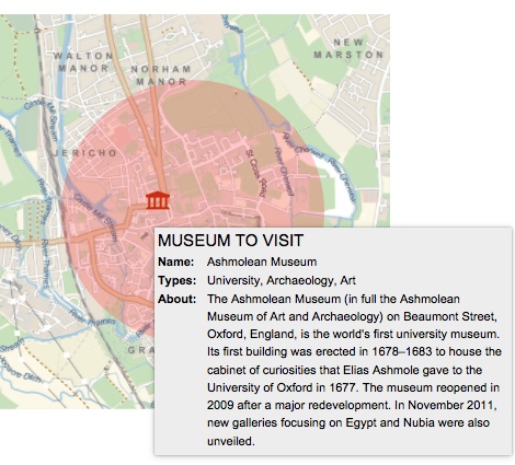
Suggest a Museum to Visit
By geo analyzing metadata from a collection of touristic photos, make suggestions about other points of interests in the same area, for example, a museum.
In[1]:=
files = Map[img \[Function] ExampleData[img, "FilePath"],
   ExampleData[{"TestImageSet", "Oxford2011"}]];
geopos = Map[file \[Function] Import[file, "GeoPosition"], files];
Compute the centroid of the locations where pictures were taken.
In[2]:=
geodata =
 GeoPosition[{Mean@geopos[[ All, 1, 1]], Mean@geopos[[All, 1, 2]],
   Mean@Cases[geopos, GeoPosition[{_, _, h_}] :> h]}]
Out[2]=
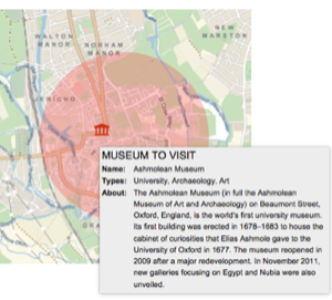
Find the closest museum.
In[3]:=
entMus = Quiet[First@GeoNearest["Museum", geodata]];In[4]:=
geoMus = Quiet[FindGeoLocation@entMus];Fetch and typeset information about this museum.
In[5]:=
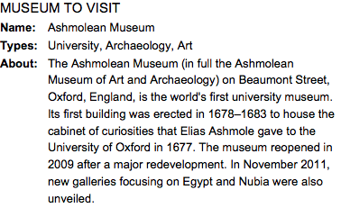
mus = EntityValue[entMus, EntityProperty["Museum", "Name"]];
type = EntityValue[entMus,
  EntityProperty["Museum", "MuseumTypes"]]; about =
 WikipediaData[mus, "SummaryPlaintext"];
description = TextGrid[{
   {Style["MUSEUM TO VISIT", 15], SpanFromLeft},
   {Style["Name:", Bold], mus},
   {Style["Types:", Bold],
    StringTake[ToString[type], {2, -2}]}, {Style["About:", Bold],
    about}
    }, ItemSize -> {{4, 30}, Automatic}]
Out[5]=
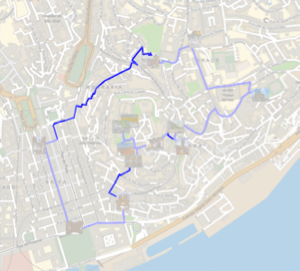
Visualize this museum's information as a tooltip on a map of the surroundings.
In[6]:=
tooltip =
  Tooltip[GeoMarker[geoMus, Entity["Icon", "Museum"]], description];
In[7]:=
GeoGraphics[{Thick, Red, GeoDisk[geodata, Quantity[1000, "Meters"]],
  tooltip}, "GeoRange" -> 1500, ImageSize -> Medium]
Out[7]=