高度に単位を付けてプロットする
アメリカ合衆国の大陸領域の高度データは,海洋部の水深5,700メートルからロッキー山脈の海抜3,700メートルまでで返される.
In[1]:=
us = GeoElevationData[\!\(\*
NamespaceBox["LinguisticAssistant",
DynamicModuleBox[{Typeset`query$$ = "lower 48", Typeset`boxes$$ =
      TemplateBox[{"\"Continental US states\"",
RowBox[{"EntityClass", "[",
RowBox[{"\"AdministrativeDivision\"", ",",
            "\"ContinentalUSStates\""}], "]"}],
        "\"EntityClass[\\\"AdministrativeDivision\\\", \
\\\"ContinentalUSStates\\\"]\"", "\"administrative divisions\""},
       "EntityClass"], Typeset`allassumptions$$ = {},
      Typeset`assumptions$$ = {}, Typeset`open$$ = {1, 2},
      Typeset`querystate$$ = {
      "Online" -> True, "Allowed" -> True,
       "mparse.jsp" -> 0.741402`6.321598746740357, "Messages" -> {}}},
DynamicBox[ToBoxes[
AlphaIntegration`LinguisticAssistantBoxes["", 4, Automatic,
Dynamic[Typeset`query$$],
Dynamic[Typeset`boxes$$],
Dynamic[Typeset`allassumptions$$],
Dynamic[Typeset`assumptions$$],
Dynamic[Typeset`open$$],
Dynamic[Typeset`querystate$$]], StandardForm],
ImageSizeCache->{323., {7., 15.}},
TrackedSymbols:>{
        Typeset`query$$, Typeset`boxes$$, Typeset`allassumptions$$,
         Typeset`assumptions$$, Typeset`open$$, Typeset`querystate$$}],
DynamicModuleValues:>{},
UndoTrackedVariables:>{Typeset`open$$}],
BaseStyle->{"Deploy"},
DeleteWithContents->True,
Editable->False,
SelectWithContents->True]\), UnitSystem -> "Meters"]
Out[1]=
In[2]:=
MinMax[us]Out[2]=
単位を自動処理し,高度を起伏地図としてプロットする.
In[3]:=
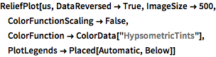
ReliefPlot[us, DataReversed -> True, ImageSize -> 500,
 ColorFunctionScaling -> False,
 ColorFunction -> ColorData["HypsometricTints"],
 PlotLegends -> Placed[Automatic, Below]]
Out[3]=
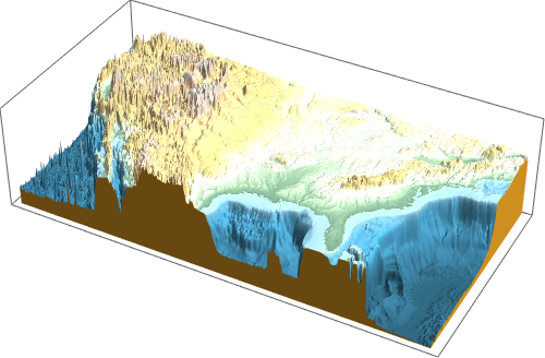
データを充填3D表面としてプロットする.
In[4]:=
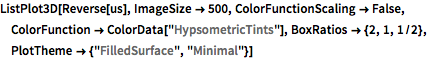
ListPlot3D[Reverse[us], ImageSize -> 500,
 ColorFunctionScaling -> False,
 ColorFunction -> ColorData["HypsometricTints"],
 BoxRatios -> {2, 1, 1/2}, PlotTheme -> {"FilledSurface", "Minimal"}]
Out[4]=