月球的新图块
版本 11 中增添了用于月球的一套改进的图块 (tile),具有 1 到 9 倍放大功能.
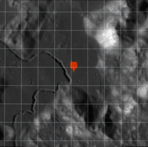
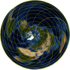
以下为阿波罗 15 号任务的着陆地点.
In[1]:=
landing =
 Entity["MannedSpaceMission", "Apollo15"][
  EntityProperty["MannedSpaceMission", "LandingPosition"]]
Out[1]=
在月球正面的正射投影图上绘制一个标记.
In[2]:=
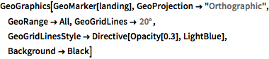
GeoGraphics[GeoMarker[landing], GeoProjection -> "Orthographic",
 GeoRange -> All, GeoGridLines -> Quantity[20, "AngularDegrees"],
 GeoGridLinesStyle -> Directive[Opacity[0.3], LightBlue],
 Background -> Black]
Out[2]=
着陆点接近雨海 (Mare Imbrium) 的东侧边缘.
In[3]:=
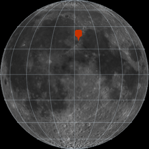
GeoGraphics[GeoMarker[landing], GeoProjection -> "Orthographic",
 GeoRange -> All, GeoGridLines -> Quantity[20, "AngularDegrees"],
 GeoGridLinesStyle -> Directive[Opacity[0.3], LightBlue],
 Background -> Black];
Show[%, GeoRange -> Quantity[200, "Miles"],
 GeoGridLines -> Quantity[2, "AngularDegrees"]]
Out[3]=
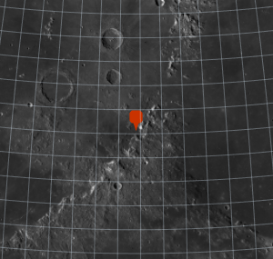
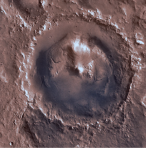
进一步放大.
In[4]:=
landing =
 Entity["MannedSpaceMission", "Apollo15"][
  EntityProperty["MannedSpaceMission", "LandingPosition"]];
Show[%, GeoRange -> Quantity[200, "Miles"],
 GeoGridLines -> Quantity[2, "AngularDegrees"]];
Show[%, GeoRange -> Quantity[15, "Miles"],
 GeoGridLines -> Quantity[.2, "AngularDegrees"]]
Out[4]=