GPS 接收器和海拔
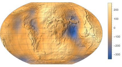
GPS 接收器测量的是相对于和地球表面的参考扁椭球近似的位置. 但是,相对于椭球的海拔却无直接的实际用处:例如,湖泊表面的海拔相对于椭球不能保持不变. 我们需要转换另一个参考面,即大地水准面,它是海平面及其延伸到内陆的近似.
大地水准面的海拔相对于参考椭球被称为 "undulation(起伏)". 下载美国本土以英尺为单位的 undulation 数据.
In[1]:=
undulation =
 GeoElevationData[Entity["Country", "UnitedStates"], "Undulation"]
Out[1]=
大地水准面总是在美国区域的参考椭球之下.
In[2]:=
MinMax[undulation]Out[2]=
特别地,这里的是在伊利诺伊州香槟市 Wolfram 总部的 undulation.
In[3]:=
GeoElevationData[
 GeoPosition[
  Entity["City", {"Champaign", "Illinois",
    "UnitedStates"}]], "Undulation"]
Out[3]=
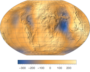
下载全球数据.
In[4]:=
undulation = GeoElevationData["World", "Undulation"]Out[4]=
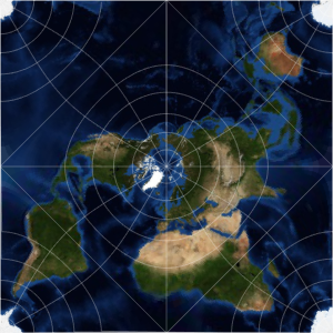
用地形图表示.
In[5]:=
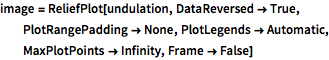
image = ReliefPlot[undulation, DataReversed -> True,
  PlotRangePadding -> None, PlotLegends -> Automatic,
  MaxPlotPoints -> Infinity, Frame -> False]
Out[5]=
使用不同地理投影.
In[6]:=
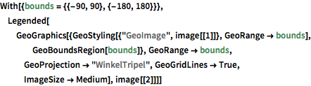
With[{bounds = {{-90, 90}, {-180, 180}}},
 Legended[GeoGraphics[{GeoStyling[{"GeoImage", image[[1]]},
     GeoRange -> bounds], GeoBoundsRegion[bounds]},
   GeoRange -> bounds, GeoProjection -> "WinkelTripel",
   GeoGridLines -> True, ImageSize -> Medium], image[[2]]]]
Out[6]=