GPS受信機と標高
GPS受信機は,地球曲面を近似する準拠扁平楕円体に対する位置を測定する.しかし楕円体に対する標高は直接利用できるものではない.例えば,ある湖の水面の標高は楕円体に対して一定ではないのである.別の準拠曲面,ジオイドに変換する必要がある.ジオイドは平均海水面を近似し,それを内陸まで延長するものである.
準拠楕円体に対するジオイド高は「起伏」と呼ばれる.アメリカ本土の起伏データ(単位:フィート)をダウンロードする.
In[1]:=
undulation =
 GeoElevationData[Entity["Country", "UnitedStates"], "Undulation"]
Out[1]=
ジオイド高はアメリカの領域内では常に準拠楕円体の値よりも低い.
In[2]:=
MinMax[undulation]Out[2]=
以下はイリノイ州シャンペーンにあるWolfram本社での起伏である.
In[3]:=
GeoElevationData[
 GeoPosition[
  Entity["City", {"Champaign", "Illinois",
    "UnitedStates"}]], "Undulation"]
Out[3]=
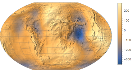
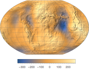
全世界のデータをダウンロードする.
In[4]:=
undulation = GeoElevationData["World", "Undulation"]Out[4]=
データを起伏図として表す.
In[5]:=
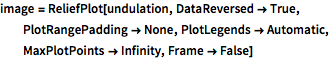
image = ReliefPlot[undulation, DataReversed -> True,
  PlotRangePadding -> None, PlotLegends -> Automatic,
  MaxPlotPoints -> Infinity, Frame -> False]
Out[5]=
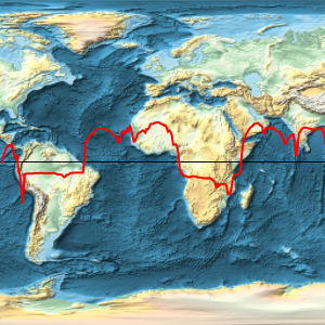
異なる投影法を使う.
In[6]:=
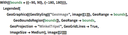
With[{bounds = {{-90, 90}, {-180, 180}}},
 Legended[GeoGraphics[{GeoStyling[{"GeoImage", image[[1]]},
     GeoRange -> bounds], GeoBoundsRegion[bounds]},
   GeoRange -> bounds, GeoProjection -> "WinkelTripel",
   GeoGridLines -> True, ImageSize -> Medium], image[[2]]]]
Out[6]=