El Marciano
Calcule, represente y mida una estimación de la trayectoria seguida por Mark Watney en el libro The Martian, cuando viaja del Ares 3 HAB al Ares 4 MAV.
Todas las posiciones en este ejemplo se refieren a posiciones en Marte. Que pueden ser especificadas explícitamente en GeoPosition, o posteriormente por medio de la opción de GeoModel.
Estas son estimaciones de las posiciones de aterrizaje de Ares 3 y 4.
ares3 = GeoPosition[{31.2, -28.5}, "Mars"];
ares4 = GeoPosition[{-4.32, 15.28}, "Mars"];
Por lo tanto, esta es la primera aproximación al viaje de Mark por Marte.
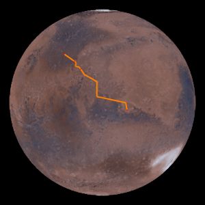
GeoGraphics[{Orange, Thick, Arrow@GeoPath[{ares3, ares4}]},
 GeoRange -> All, GeoProjection -> "Orthographic",
 Background -> Black]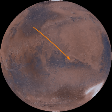
Desde Ares 3 HAB, Mark va al Marth Vallis, un valle esculpido por agua, el cual sigue.
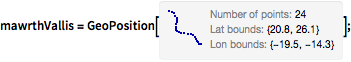
mawrthVallis = GeoPosition[CompressedData["
1:eJxTTMoPSmViYGCQAGIQLd/6OnCHnJXDN42Y/kOlxgdsua4vLvhr6QAkbbnE
jQ8wgMABS4d17g+rRNYZHZg1EwgiLaHqjQ5wgRVaOhz+ChRwMoKqt3BYAhS9
rmx0AKTLPdHCoRBksIHRgf5DQIX8Fg4iIANDjA5oAo35usLcAaLO6EDQDjmg
ixD8s2eAgMccrj4NBJ6Zwc0DK99h5vAmEMQyPACmV5s5gN3RYAixf6GZA8Re
wwNgdzbB5A0OGINAsZkDxB8GEPf5m0H8H64P9Z8ZxH+H9CDqN5tC/at3AOIu
U0h4fNWF2Kdo6uABYhzXhaj/bAL1jy5E/RUTB3A4ztQ5AAD2PaQO
"]];GeoGraphics[{Thick, Orange, Arrow@GeoPath[mawrthVallis]},
GeoModel -> "Mars", GeoRangePadding -> Quantity[100, "Miles"]]
Luego Mark pasa entre los cráteres de Trouvelot y Rutherford.
GeoPosition /@ {Entity["SolarSystemFeature", "TrouvelotMars"],
Entity["SolarSystemFeature", "RutherfordMars"]}rtCraters = GeoPosition[{17.52, -11.91}, "Mars"];Y luego viaja al cráter de Marth.
marthCrater = GeoPosition[Entity["SolarSystemFeature", "MarthMars"]]Desde allí, viaja 540 kilómetros al sur.
pos540S =
 GeoDestination[marthCrater,
GeoDisplacement[{Quantity[540, "Kilometers"], "South"}]]Y finalmente se acerca al cráter de Schiaparelli.
schiaparelliCrater = GeoPosition[{-0.16, 14.38}, "Mars"]
geopath =
  GeoPath[{{ares3, mawrthVallis[[1, 1]]},
    mawrthVallis, {mawrthVallis[[1, -1]], rtCraters, marthCrater,
     pos540S, schiaparelliCrater, ares4}}];
Esta trayectoria geográfica posee la siguiente longitud en la superficie de marte.
GeoLength[geopath, GeoModel -> "Mars"]Finalmente, agregue un número de lugares mencionados en el libro, con sus respectivas etiquetas.
labeled[pos_, label_, offset_: {Left, Bottom}] := {Point[pos],
  Text[Style[label, Directive[12, Italic, White]], pos, offset]}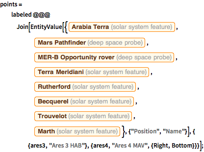
points = labeled @@@
Join[EntityValue[{Entity["SolarSystemFeature", "ArabiaTerraMars"],
Entity["DeepSpaceProbe", "MarsPathfinder"],
Entity["DeepSpaceProbe", "MERDashBOpportunityRover"],
Entity["SolarSystemFeature", "TerraMeridianiMars"],
Entity["SolarSystemFeature", "RutherfordMars"],
Entity["SolarSystemFeature", "BecquerelMars"],
Entity["SolarSystemFeature", "TrouvelotMars"],
Entity["SolarSystemFeature", "MarthMars"]}, {"Position",
"Name"}], {
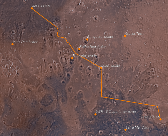
{ares3, "Ares 3 HAB"}, {ares4, "Ares 4 MAV", {Right, Bottom}}}];Este es el mapa final del viaje.
GeoGraphics[{Orange, Thick, geopath, PointSize[Large], points},
 GeoModel -> "Mars"]