Live Version Coming Soon
Check out other examples
Make a Flag Map
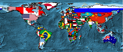
Make a world map where each country is colored with its flag.
code
With[{world = CountryData[]},
GeoGraphics[{
EdgeForm[Black],
Append[
Transpose[{
GeoStyling[{"Image", #}] & /@ Through[world["Flag"]],
Through[world["Polygon"]]
}],
{
GeoStyling[{"Image",
Entity["Country", "UnitedStates"]["Flag"]}],
\!\(\*
NamespaceBox["LinguisticAssistant",
DynamicModuleBox[{WolframAlphaClient`Private`query$$ = "Alaska",
WolframAlphaClient`Private`boxes$$ =
TemplateBox[{"\"Alaska\"",
RowBox[{"Entity", "[",
RowBox[{"\"AdministrativeDivision\"", ",",
RowBox[{"{",
RowBox[{"\"Alaska\"", ",", "\"UnitedStates\""}], "}"}]}], "]"}],
"\"Entity[\\\"AdministrativeDivision\\\", \
{\\\"Alaska\\\", \\\"UnitedStates\\\"}]\"",
"\"administrative division\""}, "Entity"],
WolframAlphaClient`Private`allassumptions$$ = {{
"type" -> "Clash", "word" -> "Alaska",
"template" -> "Assuming \"${word}\" is ${desc1}. Use as \
${desc2} instead", "count" -> "6",
"Values" -> {{
"name" -> "USState", "desc" -> "a US state",
"input" -> "*C.Alaska-_*USState-"}, {
"name" -> "MountainClass",
"desc" -> "a class of mountains",
"input" -> "*C.Alaska-_*MountainClass-"}, {
"name" -> "Movie", "desc" -> "a movie",
"input" -> "*C.Alaska-_*Movie-"}, {
"name" -> "Book", "desc" -> "a book",
"input" -> "*C.Alaska-_*Book-"}, {
"name" -> "Word", "desc" -> "a word",
"input" -> "*C.Alaska-_*Word-"}, {
"name" -> "Person", "desc" -> "a person",
"input" -> "*C.Alaska-_*Person-"}}}},
WolframAlphaClient`Private`assumptions$$ = {},
WolframAlphaClient`Private`open$$ = {1, 2}},
DynamicBox[ToBoxes[
AlphaIntegration`LinguisticAssistantBoxes["", 1,
Dynamic[WolframAlphaClient`Private`query$$],
Dynamic[WolframAlphaClient`Private`boxes$$],
Dynamic[WolframAlphaClient`Private`allassumptions$$],
Dynamic[WolframAlphaClient`Private`assumptions$$],
Dynamic[WolframAlphaClient`Private`open$$]], StandardForm],
ImageSizeCache->{92., {7., 15.}},
TrackedSymbols:>{
WolframAlphaClient`Private`query$$,
WolframAlphaClient`Private`boxes$$,
WolframAlphaClient`Private`allassumptions$$,
WolframAlphaClient`Private`assumptions$$,
WolframAlphaClient`Private`open$$}],
DynamicModuleValues:>{},
UndoTrackedVariables:>{WolframAlphaClient`Private`open$$}],
BaseStyle->{"Deploy"},
DeleteWithContents->True,
Editable->False,
SelectWithContents->True]\)["Polygon"]
}]
}, GeoBackground -> GeoStyling["ReliefMap"], ImageSize -> 500]]
how it works
This example was live-coded at the Wolfram Research booth at SXSW, March 11, 2014.
This expression makes a map with Australia indicated in black:
With[{country = \!\(\*
NamespaceBox["LinguisticAssistant",
DynamicModuleBox[{WolframAlphaClient`Private`query$$ = "Austrailia",
WolframAlphaClient`Private`boxes$$ =
TemplateBox[{"\"Australia\"",
RowBox[{"Entity", "[",
RowBox[{"\"Country\"", ",", "\"Australia\""}], "]"}],
"\"Entity[\\\"Country\\\", \\\"Australia\\\"]\"",
"\"country\""}, "Entity"],
WolframAlphaClient`Private`allassumptions$$ = {{
"type" -> "Clash", "word" -> "Austrailia",
"template" -> "Assuming \"${word}\" is ${desc1}. Use as \
${desc2} instead", "count" -> "2",
"Values" -> {{
"name" -> "Country", "desc" -> "a country",
"input" -> "*C.Austrailia-_*Country-"}, {
"name" -> "SolarSystemFeature",
"desc" -> "a solar system feature",
"input" -> "*C.Austrailia-_*SolarSystemFeature-"}}}},
WolframAlphaClient`Private`assumptions$$ = {},
WolframAlphaClient`Private`open$$ = {1, 2}},
DynamicBox[ToBoxes[
AlphaIntegration`LinguisticAssistantBoxes["", 1,
Dynamic[WolframAlphaClient`Private`query$$],
Dynamic[WolframAlphaClient`Private`boxes$$],
Dynamic[WolframAlphaClient`Private`allassumptions$$],
Dynamic[WolframAlphaClient`Private`assumptions$$],
Dynamic[WolframAlphaClient`Private`open$$]], StandardForm],
ImageSizeCache->{166., {7., 15.}},
TrackedSymbols:>{
WolframAlphaClient`Private`query$$,
WolframAlphaClient`Private`boxes$$,
WolframAlphaClient`Private`allassumptions$$,
WolframAlphaClient`Private`assumptions$$,
WolframAlphaClient`Private`open$$}],
DynamicModuleValues:>{},
UndoTrackedVariables:>{WolframAlphaClient`Private`open$$}],
BaseStyle->{"Deploy"},
DeleteWithContents->True,
Editable->False,
SelectWithContents->True]\)},
GeoGraphics[{
GeoStyling[Black],
country["Polygon"]
}, GeoBackground -> GeoStyling["ReliefMap"]
]
]
You can fill the country polygon with an arbitrary image, in this case, Australia’s flag:
With[{country = \!\(\*
NamespaceBox["LinguisticAssistant",
DynamicModuleBox[{WolframAlphaClient`Private`query$$ = "Austrailia",
WolframAlphaClient`Private`boxes$$ =
TemplateBox[{"\"Australia\"",
RowBox[{"Entity", "[",
RowBox[{"\"Country\"", ",", "\"Australia\""}], "]"}],
"\"Entity[\\\"Country\\\", \\\"Australia\\\"]\"",
"\"country\""}, "Entity"],
WolframAlphaClient`Private`allassumptions$$ = {{
"type" -> "Clash", "word" -> "Austrailia",
"template" -> "Assuming \"${word}\" is ${desc1}. Use as \
${desc2} instead", "count" -> "2",
"Values" -> {{
"name" -> "Country", "desc" -> "a country",
"input" -> "*C.Austrailia-_*Country-"}, {
"name" -> "SolarSystemFeature",
"desc" -> "a solar system feature",
"input" -> "*C.Austrailia-_*SolarSystemFeature-"}}}},
WolframAlphaClient`Private`assumptions$$ = {},
WolframAlphaClient`Private`open$$ = {1, 2}},
DynamicBox[ToBoxes[
AlphaIntegration`LinguisticAssistantBoxes["", 1,
Dynamic[WolframAlphaClient`Private`query$$],
Dynamic[WolframAlphaClient`Private`boxes$$],
Dynamic[WolframAlphaClient`Private`allassumptions$$],
Dynamic[WolframAlphaClient`Private`assumptions$$],
Dynamic[WolframAlphaClient`Private`open$$]], StandardForm],
ImageSizeCache->{166., {7., 15.}},
TrackedSymbols:>{
WolframAlphaClient`Private`query$$,
WolframAlphaClient`Private`boxes$$,
WolframAlphaClient`Private`allassumptions$$,
WolframAlphaClient`Private`assumptions$$,
WolframAlphaClient`Private`open$$}],
DynamicModuleValues:>{},
UndoTrackedVariables:>{WolframAlphaClient`Private`open$$}],
BaseStyle->{"Deploy"},
DeleteWithContents->True,
Editable->False,
SelectWithContents->True]\)},
GeoGraphics[{
GeoStyling[{"Image", country["Flag"]}],
country["Polygon"]
}, GeoBackground -> GeoStyling["ReliefMap"]
]
]
Put a crisp, black border around the flag image with EdgeForm:
With[{country = \!\(\*
NamespaceBox["LinguisticAssistant",
DynamicModuleBox[{WolframAlphaClient`Private`query$$ = "Austrailia",
WolframAlphaClient`Private`boxes$$ =
TemplateBox[{"\"Australia\"",
RowBox[{"Entity", "[",
RowBox[{"\"Country\"", ",", "\"Australia\""}], "]"}],
"\"Entity[\\\"Country\\\", \\\"Australia\\\"]\"",
"\"country\""}, "Entity"],
WolframAlphaClient`Private`allassumptions$$ = {{
"type" -> "Clash", "word" -> "Austrailia",
"template" -> "Assuming \"${word}\" is ${desc1}. Use as \
${desc2} instead", "count" -> "2",
"Values" -> {{
"name" -> "Country", "desc" -> "a country",
"input" -> "*C.Austrailia-_*Country-"}, {
"name" -> "SolarSystemFeature",
"desc" -> "a solar system feature",
"input" -> "*C.Austrailia-_*SolarSystemFeature-"}}}},
WolframAlphaClient`Private`assumptions$$ = {},
WolframAlphaClient`Private`open$$ = {1, 2}},
DynamicBox[ToBoxes[
AlphaIntegration`LinguisticAssistantBoxes["", 1,
Dynamic[WolframAlphaClient`Private`query$$],
Dynamic[WolframAlphaClient`Private`boxes$$],
Dynamic[WolframAlphaClient`Private`allassumptions$$],
Dynamic[WolframAlphaClient`Private`assumptions$$],
Dynamic[WolframAlphaClient`Private`open$$]], StandardForm],
ImageSizeCache->{166., {7., 15.}},
TrackedSymbols:>{
WolframAlphaClient`Private`query$$,
WolframAlphaClient`Private`boxes$$,
WolframAlphaClient`Private`allassumptions$$,
WolframAlphaClient`Private`assumptions$$,
WolframAlphaClient`Private`open$$}],
DynamicModuleValues:>{},
UndoTrackedVariables:>{WolframAlphaClient`Private`open$$}],
BaseStyle->{"Deploy"},
DeleteWithContents->True,
Editable->False,
SelectWithContents->True]\)},
GeoGraphics[{
EdgeForm[Black],
GeoStyling[{"Image", country["Flag"]}],
country["Polygon"]
}, GeoBackground -> GeoStyling["ReliefMap"]
]
]
Apply that technique to every country in the world. Evaluating CountryData without arguments gives a list of world countries. Here’s that list in abbreviated form:
CountryData[] // Short
This expression gives a list of {GeoStyling[...], Polygon[...]} pairs, one for each flag and country polygon—just the format required by GeoGraphics to render countries with their flags:
With[{world = CountryData[]},
Transpose[{
GeoStyling[{"Image", #}] & /@ Through[world["Flag"]],
Through[world["Polygon"]]
}]
] // Short
Use that expression within GeoGraphics to render all the countries of the world:
With[{world = CountryData[]},
GeoGraphics[{
EdgeForm[Black],
Transpose[{
GeoStyling[{"Image", #}] & /@ Through[world["Flag"]],
Through[world["Polygon"]]
}]
}, GeoBackground -> GeoStyling["ReliefMap"], ImageSize -> 500]]
The country polygon for the United States doesn’t include the widely separated area of Alaska. You can add Alaska explicitly by appending its polygon, rendered with the US flag:
With[{world = CountryData[]},
GeoGraphics[{
EdgeForm[Black],
Append[
Transpose[{
GeoStyling[{"Image", #}] & /@ Through[world["Flag"]],
Through[world["Polygon"]]
}],
{
GeoStyling[{"Image",
Entity["Country", "UnitedStates"]["Flag"]}],
\!\(\*
NamespaceBox["LinguisticAssistant",
DynamicModuleBox[{WolframAlphaClient`Private`query$$ = "Alaska",
WolframAlphaClient`Private`boxes$$ =
TemplateBox[{"\"Alaska\"",
RowBox[{"Entity", "[",
RowBox[{"\"AdministrativeDivision\"", ",",
RowBox[{"{",
RowBox[{"\"Alaska\"", ",", "\"UnitedStates\""}], "}"}]}], "]"}],
"\"Entity[\\\"AdministrativeDivision\\\", \
{\\\"Alaska\\\", \\\"UnitedStates\\\"}]\"",
"\"administrative division\""}, "Entity"],
WolframAlphaClient`Private`allassumptions$$ = {{
"type" -> "Clash", "word" -> "Alaska",
"template" -> "Assuming \"${word}\" is ${desc1}. Use as \
${desc2} instead", "count" -> "6",
"Values" -> {{
"name" -> "USState", "desc" -> "a US state",
"input" -> "*C.Alaska-_*USState-"}, {
"name" -> "MountainClass",
"desc" -> "a class of mountains",
"input" -> "*C.Alaska-_*MountainClass-"}, {
"name" -> "Movie", "desc" -> "a movie",
"input" -> "*C.Alaska-_*Movie-"}, {
"name" -> "Book", "desc" -> "a book",
"input" -> "*C.Alaska-_*Book-"}, {
"name" -> "Word", "desc" -> "a word",
"input" -> "*C.Alaska-_*Word-"}, {
"name" -> "Person", "desc" -> "a person",
"input" -> "*C.Alaska-_*Person-"}}}},
WolframAlphaClient`Private`assumptions$$ = {},
WolframAlphaClient`Private`open$$ = {1, 2}},
DynamicBox[ToBoxes[
AlphaIntegration`LinguisticAssistantBoxes["", 1,
Dynamic[WolframAlphaClient`Private`query$$],
Dynamic[WolframAlphaClient`Private`boxes$$],
Dynamic[WolframAlphaClient`Private`allassumptions$$],
Dynamic[WolframAlphaClient`Private`assumptions$$],
Dynamic[WolframAlphaClient`Private`open$$]], StandardForm],
ImageSizeCache->{236., {7., 15.}},
TrackedSymbols:>{
WolframAlphaClient`Private`query$$,
WolframAlphaClient`Private`boxes$$,
WolframAlphaClient`Private`allassumptions$$,
WolframAlphaClient`Private`assumptions$$,
WolframAlphaClient`Private`open$$}],
DynamicModuleValues:>{},
UndoTrackedVariables:>{WolframAlphaClient`Private`open$$}],
BaseStyle->{"Deploy"},
DeleteWithContents->True,
Editable->False,
SelectWithContents->True]\)["Polygon"]
}]
}, GeoBackground -> GeoStyling["ReliefMap"], ImageSize -> 500]]