GPS 수신기와 고도
GPS 수신기는 지구 표면 근사에 준거하여 편원 타원체에 대한 위치를 측정합니다. 그러나 타원체에 대한 고도는 직접 사용할 수 있는 것은 아닙니다. 예를 들어, 호수의 수면 고도는 타원체에 대해 일정하지 않기 때문에 다른 준거할 수 있는 곡면, 평균 해수면을 근사하고 그것을 내륙까지 연속시키는 지오이드로 변환 할 필요가 있습니다.
기준이 되는 타원체에 대한 지오이드 고도는 "기복"이라 칭합니다. 미국 본토의 피트 단위의 기복 데이터를 다운로드합니다.
In[1]:=
undulation =
 GeoElevationData[Entity["Country", "UnitedStates"], "Undulation"]
Out[1]=
지오이드는 미국의 영역에서 항상 기준이 되는 타원체의 아래에 있습니다.
In[2]:=
MinMax[undulation]Out[2]=
다음은 샴페인에있는 Wolfram 본사의 기복을 나타냅니다.
In[3]:=
GeoElevationData[
 GeoPosition[
  Entity["City", {"Champaign", "Illinois",
    "UnitedStates"}]], "Undulation"]
Out[3]=
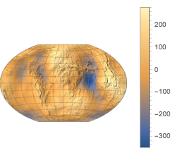
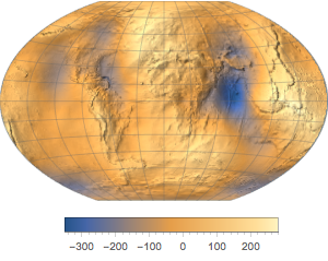
전세계의 데이터를 다운로드합니다.
In[4]:=
undulation = GeoElevationData["World", "Undulation"]Out[4]=
기복도로 표현합니다.
In[5]:=
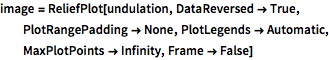
image = ReliefPlot[undulation, DataReversed -> True,
  PlotRangePadding -> None, PlotLegends -> Automatic,
  MaxPlotPoints -> Infinity, Frame -> False]
Out[5]=
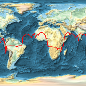
다른 투영법을 사용합니다.
In[6]:=
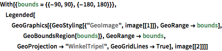
With[{bounds = {{-90, 90}, {-180, 180}}},
 Legended[GeoGraphics[{GeoStyling[{"GeoImage", image[[1]]},
     GeoRange -> bounds], GeoBoundsRegion[bounds]},
   GeoRange -> bounds, GeoProjection -> "WinkelTripel",
   GeoGridLines -> True], image[[2]]]]
Out[6]=