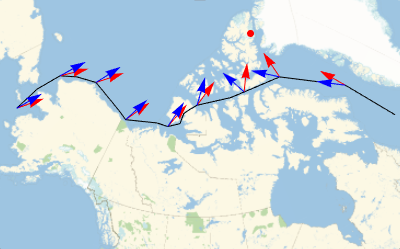
자기장 모델을 사용한 북서 항로 차트 생성
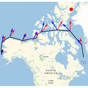
북서 항로는 대서양과 태평양을 잇는 북아메리카 해안을 따라 위치한 해로입니다. 이 항로는 1850년 발견되었으며, 탐험가 로알 아문센 (Roald Amundsen)에 의해 1903년부터 1906년까지 첫 항해가 이루어졌습니다. 고도가 높아질수록 자북과 진북의 차이가 커지므로 기존의 자석 나침반을 사용한 북서 항로의 항해에는 고충이 따릅니다. 이 예에서는 GeomagneticModelData를 사용하여 북서 항로를 그리고, 현재 지구의 자기장을 반환합니다.
북서 항로를 나타내는 위도와 경도 좌표 쌍의 목록에서 시작하여 지자기 북쪽의 위치를 취득합니다.
In[1]:=
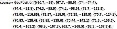
course = GeoPosition[{{60.7, -56}, {67.7, -58.5}, {74, -74.4}, {74.4, \
-91.8}, {74.3, -95.9}, {74.2, -98.5}, {73.7, -113.5}, {73.08, \
-116.86}, {72.57, -118.9}, {71.29, -119.9}, {70.7, -124.3}, {70.83, \
-128.4}, {69.85, -139.6}, {70.44, -143.1}, {71.6, -156.5}, {70.4, \
-163.2}, {68.9, -167.3}, {65.7, -168.5}, {62.3, -167.9}}];
In[2]:=
geomagneticNorthLocation =
 GeomagneticModelData["NorthGeomagneticPole"]
Out[2]=
In[3]:=
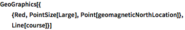
GeoGraphics[{
  {Red, PointSize[Large], Point[geomagneticNorthLocation]},
  Line[course]}]
Out[3]=
북 자극에 대한 방향 (빨간색)과 국소 자석 읽기 (파란색)를 플롯하는 함수를 정의합니다.
In[4]:=
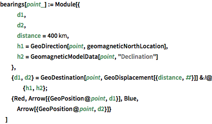
bearings[point_] := Module[{
   d1,
   d2,
   distance = Quantity[400, "Kilometers"],
   h1 = GeoDirection[point, geomagneticNorthLocation],
   h2 = GeomagneticModelData[point, "Declination"]
   },
  {d1, d2} =
   GeoDestination[point, GeoDisplacement[{distance, #}]] & /@ {h1, h2};
  {Red, Arrow[{GeoPosition@point, d1}], Blue,
   Arrow[{GeoPosition@point, d2}]}
  ]
합리적인 감각의 샘플 점을 가지고 항로를 따라 진정한 방향 (빨간색)과 자방위 (파랑)의 차이를 계산하여 시각적으로 관찰합니다.
In[5]:=
samplepoints = course[[All, {2, 3, 4, 7, 11, 13, 15, 17, 19}]];In[6]:=
GeomagneticModelData[#, "Declination"] & /@ Thread[samplepoints]Out[6]=
In[7]:=
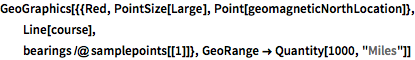
GeoGraphics[{{Red, PointSize[Large], Point[geomagneticNorthLocation]},
   Line[course],
  bearings /@ samplepoints[[1]]}, GeoRange -> Quantity[1000, "Miles"]]
Out[7]=